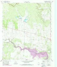
1960 Map of West Sweden
USGS Topo · Published 1988About this map
The Brady Mountains dominate the northern landscape of this McCulloch County quadrangle, falling away into a complex network of creeks and small-scale water management projects. By the early 1960s, the area near the small settlement of West Sweden was defined by significant water control efforts, including Reservoir No 43 A and Reservoir No 43 B, each featuring surveyed spillways such as Spillway 1878. The southern portion of the map showcases the expansion of the Brady Reservoir and its associated Brady Corporate Boundary, reflecting local growth and infrastructure development.
Find a feature on this map
27 named features on this map. Tap any name to fly to it.
Don’t see what you’re looking for? This feature index may not catch every label — zoom into the map to look around manually.
Map Details
Editions of this 1960 West Sweden Map
2 editions found
Other maps of this area

1892 · Eden
USGS Topo · 1:125,000

1894 · Brady
USGS Topo · 1:125,000

1896 · Eden
USGS Topo · 1:125,000

1928 · Waldrip
USGS Topo · 1:62,500

1931 · Stacy
USGS Topo · 1:62,500

1954 · Brownwood
USGS Topo · 1:250,000

1960 · West Sweden
USGS Topo · 1:24,000

1960 · Melvin
USGS Topo · 1:24,000

1960 · Brady North
USGS Topo · 1:24,000

1963 · Brady SW
USGS Topo · 1:24,000