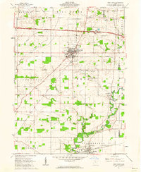
1961 Map of West Unity
USGS Topo · Published 1962About this map
West Unity serves as the central hub of this Williams County landscape, where the agricultural grid is intersected by significant transportation corridors. The village is positioned at a busy junction just south of the Ohio Turnpike, also labeled here as the Ohio Toll Road. This era captures the transition between traditional rail-dependent commerce and the rising interstate system, with the Wabash and New York Central railroads still threading through the townships of Brady and Springfield.
Find a feature on this map
37 named features on this map. Tap any name to fly to it.
Don’t see what you’re looking for? This feature index may not catch every label — zoom into the map to look around manually.
Map Details
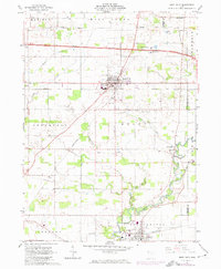
Editions of this 1961 West Unity Map
2 editions found
Other maps of this area

1907 · Defiance
USGS Topo · 1:62,500

1909 · Defiance
USGS Topo · 1:62,500

1913 · Alvordton
USGS Topo · 1:62,500

1914 · Pioneer
USGS Topo · 1:62,500

1914 · Bryan
USGS Topo · 1:62,500

1943 · Bryan
USGS Topo · 1:62,500

1944 · Pioneer
USGS Topo · 1:62,500

1944 · Alvordton
USGS Topo · 1:62,500

1953 · Fort Wayne
USGS Topo · 1:250,000

1956 · Fort Wayne
USGS Topo · 1:250,000