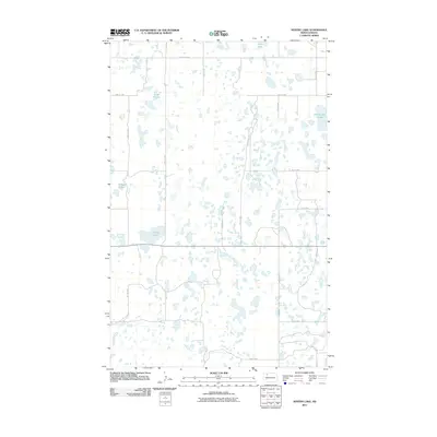
2011 Map of Westby Lake
USGS Topo · Published 2011About this map
Westby Lake and its surrounding wetlands define this prairie pothole landscape in northern Burke County during the early 21st century. The map reveals a high concentration of small, scattered water bodies characteristic of the region, including Blanc Lake, Hoover Lake, and family-named landmarks like Christensen Slough and Ford Slough. This network of glacial depressions creates a complex hydrological pattern across the rural North Dakota terrain. A rigid grid of section-line roads, such as County Rd 20 and 77th Ave NW, provides the primary structure for the area, illustrating the intersection of modern transportation with the natural drainage system of the plains. This survey captures a moment of environmental stability in a region where local water levels often dictate land use and accessibility.
Find a feature on this map
17 named features on this map. Tap any name to fly to it.
Don’t see what you’re looking for? This feature index may not catch every label — zoom into the map to look around manually.
Map Details
Editions of this 2011 Westby Lake Map
This is the sole edition of this map. No revisions or reprints were ever made.
Other maps of this area

1948 · Vanville NE
USGS Topo · 1:24,000

1949 · Mosquito Butte
USGS Topo · 1:24,000

1949 · Niobe
USGS Topo · 1:24,000

1950 · Vanville NE
USGS Topo · 1:24,000

1950 · Kenmare
USGS Topo · 1:62,500

1953 · Williston
USGS Topo · 1:250,000

1957 · Williston
USGS Topo · 1:250,000
1974 · Thompson Lake
USGS Topo · 1:24,000

1974 · Lostwood Lakes
USGS Topo · 1:24,000

1978 · Westby Lake
USGS Topo · 1:24,000