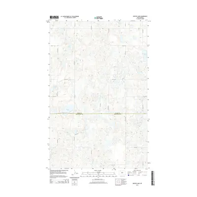
2014 Map of Westby Lake
USGS Topo · Published 2014About this map
The glacial prairie pothole region of the northern Great Plains is the defining feature of this landscape, where the boundary between Burke Co Mountrail Co divides a terrain dense with ephemeral wetlands and permanent water bodies. These depressions, known locally as sloughs, dominate the topography, with Ford Slough and Christensen Slough indicating the natural drainage patterns that have historically dictated road placement and land use. The presence of Westby Lake, Blanc Lake, and Hoover Lake further illustrates the high water table and the importance of waterfowl habitat in this part of North Dakota. A sparse grid of local roads, including CR-20 and 82nd St NW, provides the only structural overlay on a territory where the natural hydrography remains the primary landmark.
Find a feature on this map
12 named features on this map. Tap any name to fly to it.
Don’t see what you’re looking for? This feature index may not catch every label — zoom into the map to look around manually.
Map Details
Editions of this 2014 Westby Lake Map
This is the sole edition of this map. No revisions or reprints were ever made.
Other maps of this area

1948 · Vanville NE
USGS Topo · 1:24,000

1949 · Mosquito Butte
USGS Topo · 1:24,000

1949 · Niobe
USGS Topo · 1:24,000

1950 · Vanville NE
USGS Topo · 1:24,000

1950 · Kenmare
USGS Topo · 1:62,500

1953 · Williston
USGS Topo · 1:250,000

1957 · Williston
USGS Topo · 1:250,000
1974 · Thompson Lake
USGS Topo · 1:24,000

1974 · Lostwood Lakes
USGS Topo · 1:24,000

1978 · Westby Lake
USGS Topo · 1:24,000