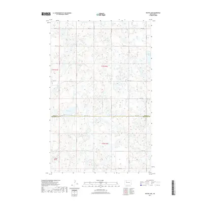
2017 Map of Westby Lake
USGS Topo · Published 2017About this map
The boundary between Burke and Mountrail counties defines this section of the North Dakota prairie, characterized by a complex network of seasonal wetlands and glacial lakes. Westby Lake sits at the center of this hydrographic landscape, surrounded by smaller water bodies like Jensen Lake and Hoover Lake. The terrain is a classic pothole region, where depressions in the glacial till collect water, forming essential features like Ford Slough and Christensen Slough. A strictly orthogonal grid of rural routes, including 83rd St NW and 78th St NW, provides the only structural overlay on this undulating natural surface. This late-stage survey captures the persistent rural character of the High Plains, where the land remains divided by the original township and range system, seen here across portions of t159n r90w and t158n r90w.
Find a feature on this map
17 named features on this map. Tap any name to fly to it.
Don’t see what you’re looking for? This feature index may not catch every label — zoom into the map to look around manually.
Map Details
Editions of this 2017 Westby Lake Map
This is the sole edition of this map. No revisions or reprints were ever made.
Other maps of this area

1948 · Vanville NE
USGS Topo · 1:24,000

1949 · Mosquito Butte
USGS Topo · 1:24,000

1949 · Niobe
USGS Topo · 1:24,000

1950 · Vanville NE
USGS Topo · 1:24,000

1950 · Kenmare
USGS Topo · 1:62,500

1953 · Williston
USGS Topo · 1:250,000

1957 · Williston
USGS Topo · 1:250,000
1974 · Thompson Lake
USGS Topo · 1:24,000

1974 · Lostwood Lakes
USGS Topo · 1:24,000

1978 · Westby Lake
USGS Topo · 1:24,000