
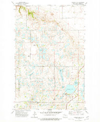
1978 Map of Westby Lake
USGS Topo · Published 1978About this map
Kandiyohi and Sidonia townships define this portion of the North Dakota prairie, characterized by an intricate network of wetlands and small water bodies. The 1978 topography reveals a landscape dominated by glacial potholes, including Westby Lake, Jensen Lake, and Blanc Lake. These natural depressions are interspersed with named marshlands like Ford Slough and Christensen Slough, creating a complex aquatic system that influenced the placement of early rural infrastructure. Evidence of small-scale community centers is found at the Ecklund School in the north and the Sidonia School further south, both situated along section-line roads that navigate around the numerous lakes and sloughs. A single Gravel Pit indicates local industrial activity, while the boundary between Burke Co and Mountrail Co runs through the heart of this wetland-rich prairie.
Find a feature on this map
15 named features on this map. Tap any name to fly to it.
Don’t see what you’re looking for? This feature index may not catch every label — zoom into the map to look around manually.
Map Details
Editions of this 1978 Westby Lake Map
This is the sole edition of this map. No revisions or reprints were ever made.
Other maps of this area

1948 · Vanville NE
USGS Topo · 1:24,000

1949 · Mosquito Butte
USGS Topo · 1:24,000

1949 · Niobe
USGS Topo · 1:24,000

1950 · Vanville NE
USGS Topo · 1:24,000

1950 · Kenmare
USGS Topo · 1:62,500

1953 · Williston
USGS Topo · 1:250,000

1957 · Williston
USGS Topo · 1:250,000
1974 · Thompson Lake
USGS Topo · 1:24,000

1974 · Lostwood Lakes
USGS Topo · 1:24,000

1981 · Lostwood
USGS Topo · 1:24,000