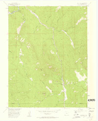
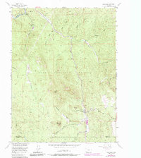
1956 Map of Westcreek
USGS Topo · Published 1958About this map
Westcreek sits at the intersection of Douglas, Teller, and Jefferson counties, serving as a hub for the ranches and mountain camps of the mid-1950s. The settlement pattern follows the drainage of West Creek, where small-scale operations like the Quarry and local landmarks like Bell Rock define the local geography. A mix of seasonal and permanent residency is evident in the presence of the Grandview Resort and Shady Brook Camp, alongside family-held lands such as Pollock Ranch and Fletcher Ranch.
Find a feature on this map
33 named features on this map. Tap any name to fly to it.
Don’t see what you’re looking for? This feature index may not catch every label — zoom into the map to look around manually.
Map Details
Editions of this 1956 Westcreek Map
5 editions found
Other maps of this area

1893 · Platte Canyon
USGS Topo · 1:125,000

1953 · Denver
USGS Topo · 1:250,000

1954 · Devils Head
USGS Topo · 1:24,000

1954 · Deckers
USGS Topo · 1:24,000

1954 · Green Mountain
USGS Topo · 1:24,000

1954 · Mount Deception
USGS Topo · 1:24,000

1954 · Signal Butte
USGS Topo · 1:24,000
1956 · Dakan Mountain
USGS Topo · 1:24,000

1956 · Hackett Mountain
USGS Topo · 1:24,000
1956 · Cheesman Lake
USGS Topo · 1:24,000