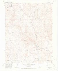
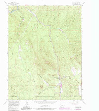
1956 Map of Westcreek
USGS Topo · Published 1966About this map
The South Platte River and its network of tributaries define this mid-century look at the granite-heavy topography of Pike National Forest. Following the course of West Creek and Trout Creek, the landscape is dotted with several private holdings and recreation sites, such as Grandview Resort and the Shady Brook Camp (YMCA). These small settlements and ranching operations, including Fletcher Ranch and Orion Ranch, reflect the area's history of summer retreats and livestock grazing before modern development. Notable landmarks such as Thunder Butte and Bell Rock dominate the vertical relief, while the small community of Westcreek serves as a local hub near Westervek Lake. Remnants of earlier industry are visible at a Quarry near the Cem, indicating the extraction of local materials alongside a shifting economy toward tourism and leisure.
Find a feature on this map
34 named features on this map. Tap any name to fly to it.
Don’t see what you’re looking for? This feature index may not catch every label — zoom into the map to look around manually.
Map Details
Editions of this 1956 Westcreek Map
5 editions found
Other maps of this area

1893 · Platte Canyon
USGS Topo · 1:125,000

1953 · Denver
USGS Topo · 1:250,000

1954 · Devils Head
USGS Topo · 1:24,000

1954 · Deckers
USGS Topo · 1:24,000

1954 · Green Mountain
USGS Topo · 1:24,000

1954 · Mount Deception
USGS Topo · 1:24,000

1954 · Signal Butte
USGS Topo · 1:24,000
1956 · Dakan Mountain
USGS Topo · 1:24,000

1956 · Hackett Mountain
USGS Topo · 1:24,000
1956 · Cheesman Lake
USGS Topo · 1:24,000