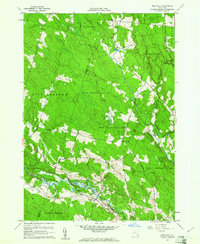
1959 Map of Westdale
USGS Topo · Published 1973About this map
Westdale sits at the junction of rail and river in the late 1950s, serving as a gateway to the heavily forested interior of northern Oneida County. The landscape is defined by extensive State Reforestation Areas, reflecting mid-century land conservation efforts across the Tug Hill plateau region. Moving north from the West Branch and the quiet waters of Gifford Lake, the terrain rises into the Camden Woods and toward the crossroads at Florence Hill.
Find a feature on this map
44 named features on this map. Tap any name to fly to it.
Don’t see what you’re looking for? This feature index may not catch every label — zoom into the map to look around manually.
Map Details
Editions of this 1959 Westdale Map
3 editions found
Other maps of this area

1903 · Orwell
USGS Topo · 1:62,500

1905 · Orwell
USGS Topo · 1:62,500

1905 · Taberg
USGS Topo · 1:62,500

1906 · Highmarket
USGS Topo · 1:62,500

1906 · Kasoag
USGS Topo · 1:62,500

1942 · Redfield
USGS Topo · 1:24,000

1943 · Redfield
USGS Topo · 1:31,680

1943 · Westdale
USGS Topo · 1:31,680

1943 · Camden West
USGS Topo · 1:31,680

1943 · East Florence
USGS Topo · 1:31,680