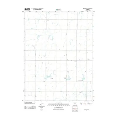
2011 Map of Western SE
USGS Topo · Published 2011About this map
Swanton Cemetery and Old Plymouth Cemetery anchor this rural landscape in Saline County, where the agricultural grid is defined by a dense network of avenues and roads. The terrain is marked by the sophisticated water management of the Cub Creek watershed, featuring a series of catchments including Cub Creek Reservoir 12-D, Cub Creek Reservoir 12-C, and Cub Creek Reservoir 10-A. These engineered bodies of water, supported by structures like Floodwater Retarding Dam 12-C, illustrate the mid-to-late 20th-century efforts to stabilize the drainage of Swan Creek and the larger Cub Creek system. Small country burial grounds such as Megli Cemetery, Emmanuel Cemetery, and Saint Paul Cemetery are scattered throughout the sections, serving as vital landmarks for genealogists tracing early prairie families in this part of Nebraska.
Find a feature on this map
27 named features on this map. Tap any name to fly to it.
Don’t see what you’re looking for? This feature index may not catch every label — zoom into the map to look around manually.
Map Details
Editions of this 2011 Western SE Map
This is the sole edition of this map. No revisions or reprints were ever made.
Other maps of this area

1955 · Lincoln
USGS Topo · 1:250,000

1957 · Lincoln
USGS Topo · 1:250,000

1957 · Plymouth
USGS Topo · 1:24,000

1957 · Wilber
USGS Topo · 1:24,000

1958 · Lincoln
USGS Topo · 1:250,000

1960 · Western SW
USGS Topo · 1:24,000

1960 · Fairbury
USGS Topo · 1:24,000

1961 · Western
USGS Topo · 1:24,000

1961 · Western SE
USGS Topo · 1:24,000
1961 · Swanton
USGS Topo · 1:24,000