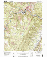
1996 Map of Westernport
USGS Topo · Published 2002About this map
Westernport and Piedmont anchor this industrial river valley, where the North Branch Potomac River serves as the boundary between Maryland and West Virginia. This landscape is defined by the extraction economy of the Allegheny Front, with numerous Former Mines and Strip Mines dotting the terrain from Franklin Hill to the heights of Dans Mtn. The transport network of the late 20th century is clearly visible, featuring the W Va Central Junc and local roads like Seldom Seen Road and Backbone Road. Genealogists and local historians can locate several rural landmarks including the Cross School, Duling Ch, and family-named cemeteries such as Tichnell Cem and Shikler Cem. The map captures the significant environmental footprint of the region, from the Bloomington Lake reservoir to the extensive wildlife areas like the Allegheny State Wildlife Management Area.
Find a feature on this map
59 named features on this map. Tap any name to fly to it.
Don’t see what you’re looking for? This feature index may not catch every label — zoom into the map to look around manually.
Map Details
Editions of this 1996 Westernport Map
This is the sole edition of this map. No revisions or reprints were ever made.
Other maps of this area

1891 · Romney
USGS Topo · 1:125,000

1895 · Piedmont
USGS Topo · 1:125,000

1898 · Frostburg
USGS Topo · 1:62,500

1899 · Grantsville
USGS Topo · 1:62,500

1901 · Frostburg
USGS Topo · 1:62,500

1904 · Grantsville
USGS Topo · 1:62,500

1908 · Frostburg
USGS Topo · 1:62,500

1919 · Elk Garden
USGS Topo · 1:48,000

1920 · Elk Garden
USGS Topo · 1:48,000

1920 · Keyser
USGS Topo · 1:62,500