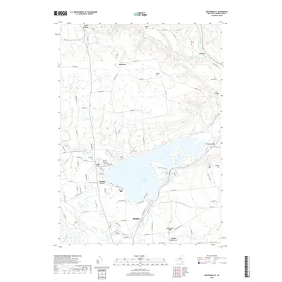
2019 Map of Westernville
USGS Topo · Published 2019About this map
Delta Reservoir dominates the central landscape, a significant water body created by the damming of the Mohawk River north of Rome. This modern survey reveals the evolved layout of rural Oneida County, where the historic path of the Black River Canal can still be traced along the reservoir's eastern shore near Westernville. The surrounding terrain is defined by elevated features like Quaker Hill and Haynes Hill, which overlook a network of smaller streams such as Lansing Kill and McMullen Brook. For local historians and genealogists, the map provides precise locations for several community landmarks, including Welsh Cem in the north and the Polish Cem further south. Smaller crossroads and residential clusters like Beartown, Hillside, and Hawkins Corner illustrate the persistent settlement patterns in this part of the Mohawk Valley, while Delta Lake State Park highlights the area's transition into a regional recreational hub.
Find a feature on this map
112 named features on this map. Tap any name to fly to it.
Don’t see what you’re looking for? This feature index may not catch every label — zoom into the map to look around manually.
Map Details
Editions of this 2019 Westernville Map
This is the sole edition of this map. No revisions or reprints were ever made.
Other maps of this area

1895 · Oriskany
USGS Topo · 1:62,500

1895 · Oneida
USGS Topo · 1:62,500

1898 · Oneida
USGS Topo · 1:62,500

1898 · Oriskany
USGS Topo · 1:62,500

1902 · Oneida
USGS Topo · 1:62,500

1904 · Boonville
USGS Topo · 1:62,500

1905 · Taberg
USGS Topo · 1:62,500

1939 · Oneida
USGS Topo · 1:62,500

1943 · Lee Center
USGS Topo · 1:31,680

1944 · Point Rock
USGS Topo · 1:31,680