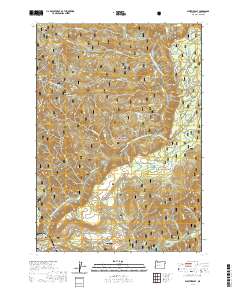
2020 Map of Westfir East
USGS Topo · Published 2020About this map
Oakridge and the neighboring settlements of Westfir and Willamette City sit at the convergence of mountain waters within the Willamette National Forest. The landscape is dominated by the North Fork Middle Fork Willamette River, which flows through a complex network of named tributaries such as Salmon Creek and McLane Creek. This modern survey illustrates the heavy recreational and administrative footprint in the region, particularly through the extensive Huckleberry Flats ATV trail system and the presence of the Oakridge State Airport. Notable landmarks include the Office Bridge and Forestvale Cemetery, which provide points of reference for local history. The surrounding peaks, including Dead Mountain, Buckhead Mountain, and Sourgrass Mountain, define the high-elevation terrain and separate the various drainage basins that feed into the Willamette system.
Find a feature on this map
59 named features on this map. Tap any name to fly to it.
Don’t see what you’re looking for? This feature index may not catch every label — zoom into the map to look around manually.
Map Details
Editions of this 2020 Westfir East Map
This is the sole edition of this map. No revisions or reprints were ever made.
Other maps of this area

1925 · Waldo Lake
USGS Topo · 1:125,000

1935 · Lowell
USGS Topo · 1:96,000

1942 · Lowell
USGS Topo · 1:125,000

1955 · Hardesty Mtn
USGS Topo · 1:62,500

1955 · Fairview Peak
USGS Topo · 1:62,500

1956 · Oakridge
USGS Topo · 1:62,500

1956 · Sardine Butte
USGS Topo · 1:62,500

1958 · Roseburg
USGS Topo · 1:250,000

1959 · Roseburg
USGS Topo · 1:250,000

1983 · Oakridge
USGS Topo · 1:100,000