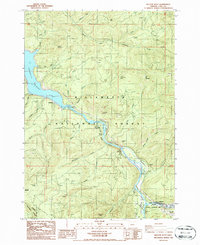
1986 Map of Westfir West
USGS Topo · Published 1986About this map
Lookout Point Lake dominates the central corridor of this mid-1980s landscape, where the waters of the Middle Fork Willamette River are managed alongside the industrial infrastructure of the Southern Pacific railroad. The map documents a heavily managed timber and recreational environment within the Willamette National Forest and Umpqua National Forest. Evidence of the region's logging and transit economy is seen in the numerous Quarry and Borrow Pit sites scattered across the terrain, serving the mountain roads that climb toward summits like Patterson Mountain and Tire Mountain. Recreational development is concentrated along the river corridor, featuring the Black Canyon Campground, Shady Dell Campground, and the Hampton Boating Site. On the eastern edge, the topography descends toward the Oakridge Airport, marking the transition from high-elevation forest to the valley floor's transportation hub.
Find a feature on this map
44 named features on this map. Tap any name to fly to it.
Don’t see what you’re looking for? This feature index may not catch every label — zoom into the map to look around manually.
Map Details
Editions of this 1986 Westfir West Map
This is the sole edition of this map. No revisions or reprints were ever made.
Other maps of this area

1925 · Waldo Lake
USGS Topo · 1:125,000

1935 · Lowell
USGS Topo · 1:96,000

1942 · Lowell
USGS Topo · 1:125,000

1955 · Hardesty Mtn
USGS Topo · 1:62,500

1955 · Fairview Peak
USGS Topo · 1:62,500

1956 · Oakridge
USGS Topo · 1:62,500

1956 · Sardine Butte
USGS Topo · 1:62,500

1958 · Roseburg
USGS Topo · 1:250,000

1959 · Roseburg
USGS Topo · 1:250,000

1983 · Oakridge
USGS Topo · 1:100,000