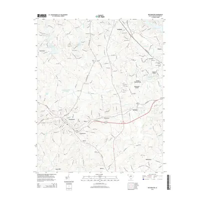
2014 Map of Westminster
USGS Topo · Published 2014About this map
The town of Westminster and the southern edge of Walhalla anchor this landscape during a period of modern development in Oconee County. The Norfolk Southern rail line serves as a central corridor through the region, passing through Eastminster and Richland before exiting the sheet near the growing neighborhoods of Ridgeland Estates and Oconee Estates. This 2014 survey documents a complex hydrological system, where the waters of Coneross Cr and its tributaries have been utilized for numerous reservoirs, including the Coneross Watershed 9-A Reservoir and Negro Fork Reservoir. In the northeast corner, the presence of Lake Keowee and Cane Creek highlights the proximity to the Blue Ridge foothills. Scattered rural burial grounds such as Flat Rock Cem and Pleasant Hill Cem provide essential geographic markers for genealogists and local historians studying the long-standing community foundations of the area.
Find a feature on this map
192 named features on this map. Tap any name to fly to it.
Don’t see what you’re looking for? This feature index may not catch every label — zoom into the map to look around manually.
Map Details
Editions of this 2014 Westminster Map
This is the sole edition of this map. No revisions or reprints were ever made.
Other maps of this area

1886 · Walhalla
USGS Topo · 1:125,000

1888 · Pickens
USGS Topo · 1:125,000

1892 · Walhalla
USGS Topo · 1:125,000

1894 · Pickens
USGS Topo · 1:125,000

1896 · Walhalla
USGS Topo · 1:125,000

1954 · Greenville
USGS Topo · 1:250,000

1958 · Greenville
USGS Topo · 1:250,000

1958 · Seneca
USGS Topo · 1:24,000

1958 · Fair Play
USGS Topo · 1:24,000
1959 · Walhalla
USGS Topo · 1:24,000