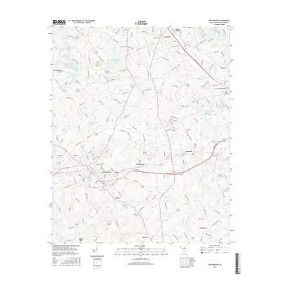
2017 Map of Westminster
USGS Topo · Published 2017About this map
Westminster and Walhalla anchor this corner of Oconee County, showing a landscape shaped by water management and transit. The Norfolk Southern railroad cuts through the southern portion of the quadrangle, passing through the settlements of Jason, Westminster, and Richland. This infrastructure mirrors the modern drainage patterns created by the Coneross Watershed 9-A Reservoir and Coneross Watershed 9-I Reservoir, which regulate the flow of Coneross Cr across the central plains.
Find a feature on this map
190 named features on this map. Tap any name to fly to it.
Don’t see what you’re looking for? This feature index may not catch every label — zoom into the map to look around manually.
Map Details
Editions of this 2017 Westminster Map
This is the sole edition of this map. No revisions or reprints were ever made.
Other maps of this area

1886 · Walhalla
USGS Topo · 1:125,000

1888 · Pickens
USGS Topo · 1:125,000

1892 · Walhalla
USGS Topo · 1:125,000

1894 · Pickens
USGS Topo · 1:125,000

1896 · Walhalla
USGS Topo · 1:125,000

1954 · Greenville
USGS Topo · 1:250,000

1958 · Greenville
USGS Topo · 1:250,000

1958 · Seneca
USGS Topo · 1:24,000

1958 · Fair Play
USGS Topo · 1:24,000
1959 · Walhalla
USGS Topo · 1:24,000