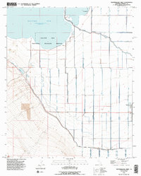
1992 Map of Westmorland West
USGS Topo · Published 1995About this map
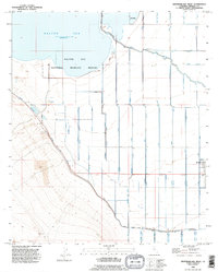
The Salton Sea dominates the northern horizon of this Imperial Valley landscape, its shoreline recorded at an elevation 228 feet below sea level during this survey. Much of the northern terrain is dedicated to the Salton Sea National Wildlife Refuge, where a complex system of levees manages the transition between open water and the agricultural grid. To the south and east, the desert has been transformed into a highly engineered irrigation network. The New River snakes across the plain, joined by an intricate series of man-made waterways including the Westside Main Canal, the Trifolium Extension, and the Thistle Canal. The small settlement of Westmorland anchors the eastern edge of the map, serving as a hub for the surrounding fields. Industrial activity is visible in the southwest, where various pits and a Gravel Pit indicate local resource extraction amidst the canals and drains.
Find a feature on this map
46 named features on this map. Tap any name to fly to it.
Don’t see what you’re looking for? This feature index may not catch every label — zoom into the map to look around manually.
Map Details
Editions of this 1992 Westmorland West Map
2 editions found
Other maps of this area

1915 · El Centro
USGS Topo · 1:125,000

1940 · Brawley
USGS Topo · 1:62,500

1940 · Kane Spring
USGS Topo · 1:62,500

1940 · Plaster City
USGS Topo · 1:62,500

1942 · El Centro
USGS Topo · 1:250,000

1943 · Brawley
USGS Topo · 1:62,500

1944 · Plaster City
USGS Topo · 1:62,500

1944 · Kane Spring
USGS Topo · 1:62,500

1944 · Calipatria
USGS Topo · 1:62,500

1954 · El Centro
USGS Topo · 1:250,000