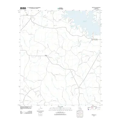
2012 Map of Weston
USGS Topo · Published 2012About this map
Caney Creek Reservoir dominates the northern reaches of this Jackson Parish landscape, its finger-like coves carving into the surrounding hills. The topography is defined by a dense network of tributaries including Brown Creek, Beech Creek, and Hurricane Creek, which flow through a primarily rural area marked by small-scale settlements. Near the reservoir, the community of Mount Hebron and its associated Mount Hebron Cemetery provide a focal point for local history, while the southern portion of the quadrangle is anchored by the village of Walker and the more remote Transport Cemetery on Parish Road 1193. This 2012 survey illustrates the transition of the region from a purely agricultural and timber landscape to one influenced by the recreational draw of the reservoir, as seen in the development of numerous residential lanes like Hummingbird Drive and Wild Rose Drive.
Find a feature on this map
101 named features on this map. Tap any name to fly to it.
Don’t see what you’re looking for? This feature index may not catch every label — zoom into the map to look around manually.
Map Details
Editions of this 2012 Weston Map
This is the sole edition of this map. No revisions or reprints were ever made.
Other maps of this area

1949 · Jonesboro
USGS Topo · 1:62,500

1950 · Jonesboro
USGS Topo · 1:62,500

1953 · Chatham
USGS Topo · 1:62,500

1953 · Hodge
USGS Topo · 1:62,500

1954 · Sikes
USGS Topo · 1:62,500

1955 · Shreveport
USGS Topo · 1:250,000

1956 · Shreveport
USGS Topo · 1:250,000

1982 · Chatham
USGS Topo · 1:24,000

1984 · Shreveport
USGS Topo · 1:250,000
1985 · Monroe South
USGS Topo · 1:100,000