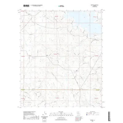
2020 Map of Weston
USGS Topo · Published 2020About this map
Weston and Walker anchor this northern Louisiana landscape, where the wooded hills of Jackson Parish meet the border of Winn Parish. The terrain is defined by a dense network of drainages including Beech Cr, Hurricane Cr, and Wolf Cr, which feed into larger systems like the Caney Creek Reservoir in the northeast corner. This reservoir serves as a significant geographic landmark, contrasted by the rural road networks like Walker Rd and Parish Rd 475 that connect isolated homesteads and community centers. For those tracing local heritage, several notable burial sites are documented across the sections, such as Mount Hebron Cem near the eastern boundary and Midway Baptist Cem. The southern reach of the survey is marked by the flow of Pepper Br and Flat Cr, illustrating the typical creek-bottom topography of the region's timber and agricultural lands.
Find a feature on this map
99 named features on this map. Tap any name to fly to it.
Don’t see what you’re looking for? This feature index may not catch every label — zoom into the map to look around manually.
Map Details
Editions of this 2020 Weston Map
This is the sole edition of this map. No revisions or reprints were ever made.
Other maps of this area

1949 · Jonesboro
USGS Topo · 1:62,500

1950 · Jonesboro
USGS Topo · 1:62,500

1953 · Chatham
USGS Topo · 1:62,500

1953 · Hodge
USGS Topo · 1:62,500

1954 · Sikes
USGS Topo · 1:62,500

1955 · Shreveport
USGS Topo · 1:250,000

1956 · Shreveport
USGS Topo · 1:250,000

1982 · Chatham
USGS Topo · 1:24,000

1984 · Shreveport
USGS Topo · 1:250,000
1985 · Monroe South
USGS Topo · 1:100,000