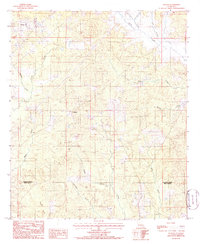
1985 Map of Weston
USGS Topo · Published 1986About this map
Weston and Walker serve as the primary nodes of settlement in this 1980s landscape, which spans the border of Jackson Parish and Winn Parish. The area is defined by an intricate network of waterways draining the timberlands, including Caney Creek and Cypress Creek to the north, and Hurricane Creek winding toward the southern boundary. These stream patterns, alongside landmarks like Pepper Branch and Kiesche Creek, dictate the rural road layout and the placement of local homesteads. The terrain transitions from the headwaters of Halfway Creek to the broad drainage of Flat Creek, illustrating the natural topography of North Louisiana before significant modern commercial expansion. This provisional survey captures the quiet, interior character of the piney woods parishes at a time when local life was still closely tied to the creek-side geography.
Find a feature on this map
16 named features on this map. Tap any name to fly to it.
Don’t see what you’re looking for? This feature index may not catch every label — zoom into the map to look around manually.
Map Details
Editions of this 1985 Weston Map
This is the sole edition of this map. No revisions or reprints were ever made.
Other maps of this area

1949 · Jonesboro
USGS Topo · 1:62,500

1950 · Jonesboro
USGS Topo · 1:62,500

1953 · Chatham
USGS Topo · 1:62,500

1953 · Hodge
USGS Topo · 1:62,500

1954 · Sikes
USGS Topo · 1:62,500

1955 · Shreveport
USGS Topo · 1:250,000

1956 · Shreveport
USGS Topo · 1:250,000

1982 · Chatham
USGS Topo · 1:24,000

1984 · Shreveport
USGS Topo · 1:250,000
1985 · Monroe South
USGS Topo · 1:100,000