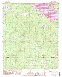
1994 Map of Weston
USGS Topo · Published 1995About this map
Caney Creek Reservoir dominates the northeastern landscape of this North Louisiana region, with its irregular fingers stretching into the timbered hills. Situated along the boundary where Jackson and Winn Parishes meet, the area features the recreation-focused Caney Creek Lake State Park. Small settlements like Weston and Walker are connected by a network of local roads that navigate a dense drainage system. Numerous watercourses, including Hurricane Creek, Hathaway Creek, and Kiesche Creek, carve through the terrain, suggesting a landscape defined by forestry and watershed management. A solitary Cem (cemetery) located near the parish line provides a specific point of interest for genealogists tracing family roots in this rural corridor between small rural communities. The map reflects a mid-1990s perspective, capturing the development of the reservoir alongside older established homesteads.
Find a feature on this map
17 named features on this map. Tap any name to fly to it.
Don’t see what you’re looking for? This feature index may not catch every label — zoom into the map to look around manually.
Map Details
Editions of this 1994 Weston Map
This is the sole edition of this map. No revisions or reprints were ever made.
Other maps of this area

1949 · Jonesboro
USGS Topo · 1:62,500

1950 · Jonesboro
USGS Topo · 1:62,500

1953 · Chatham
USGS Topo · 1:62,500

1953 · Hodge
USGS Topo · 1:62,500

1954 · Sikes
USGS Topo · 1:62,500

1955 · Shreveport
USGS Topo · 1:250,000

1956 · Shreveport
USGS Topo · 1:250,000

1982 · Chatham
USGS Topo · 1:24,000

1984 · Shreveport
USGS Topo · 1:250,000
1985 · Monroe South
USGS Topo · 1:100,000