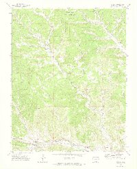
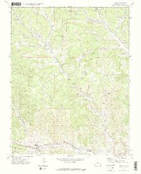
1971 Map of Weston
USGS Topo · Published 1974About this map
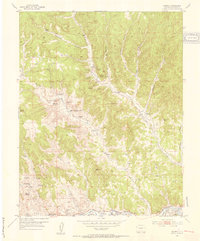
The Purgatoire River carves through the landscape of southern Colorado, anchoring a corridor of historical settlement and transit. This early 1970s survey captures the established communities of Weston, Cordova Plaza, and Medina Plaza situated along the valley floor. The map records the infrastructure of the era, including the Purgatoire and Miranda RR Grade and a significant Aqueduct, illustrating how water and rail management defined life in this semi-arid region. To the north, the terrain transitions into the Spanish Peaks State Wildlife Area, marked by complex drainages like Sarcillo Canyon and Upper Burro Canyon. Local history is preserved through the locations of the Esquipula Ch, the Pacheco Cem, and schools such as Primero HS, providing a detailed view of the social fabric and ranching heritage of Las Animas County.
Find a feature on this map
40 named features on this map. Tap any name to fly to it.
Don’t see what you’re looking for? This feature index may not catch every label — zoom into the map to look around manually.
Map Details
Editions of this 1971 Weston Map
3 editions found
Other maps of this area

1891 · Spanish Peaks
USGS Topo · 1:125,000

1893 · Spanish Peaks
USGS Topo · 1:125,000

1895 · Spanish Peaks
USGS Topo · 1:125,000

1897 · Spanish Peaks
USGS Topo · 1:125,000

1900 · Spanish Peaks
USGS Topo · 1:125,000
1951 · Valdez
USGS Topo · 1:24,000
1951 · Madrid
USGS Topo · 1:24,000

1954 · Trinidad
USGS Topo · 1:250,000

1955 · Trinidad
USGS Topo · 1:250,000

1958 · Trinidad
USGS Topo · 1:250,000