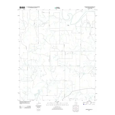
2013 Map of Westover SE
USGS Topo · Published 2013About this map
The Brazos River meanders through the northeast corner of this Throckmorton County landscape, carving a distinct path through the Westover SE quadrangle. Characterized by a network of ranch and county roads, the area shows the infrastructure of the local energy and agriculture economy, most notably at the Lendra Oil Field. Named drainages including Hog Cr, Boggy Cr, and Leopard Cr define the hydrological layout, feeding into small catchments like Keeter Lake. This survey illustrates the sparse, rural nature of North Texas, where place-names like Coon Hollow and family-named routes such as Bellomy Cribs Cantrell Rd and Spade Ranch Rd reflect the heritage of the land and its long-standing property divisions.
Find a feature on this map
30 named features on this map. Tap any name to fly to it.
Don’t see what you’re looking for? This feature index may not catch every label — zoom into the map to look around manually.
Map Details
Editions of this 2013 Westover SE Map
This is the sole edition of this map. No revisions or reprints were ever made.
Other maps of this area

1954 · Wichita Falls
USGS Topo · 1:250,000

1958 · Wichita Falls
USGS Topo · 1:250,000

1963 · Megargel
USGS Topo · 1:24,000

1964 · Padgett
USGS Topo · 1:24,000

1965 · Throckmorton NE
USGS Topo · 1:24,000

1966 · Westover SE
USGS Topo · 1:24,000

1966 · Rock Canyon
USGS Topo · 1:24,000

1966 · Westover SW
USGS Topo · 1:24,000
1966 · Throckmorton
USGS Topo · 1:24,000
1966 · Westover
USGS Topo · 1:24,000