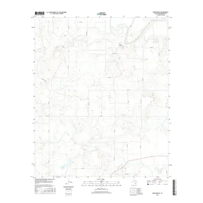
2016 Map of Westover SE
USGS Topo · Published 2016About this map
The Brazos River meanders through the northeastern corner of this Westover SE landscape, defining the local hydrology alongside smaller tributaries like Hog Cr and Leopard Cr. The terrain is marked by distinct features such as Coon Hollow and the southern basin of Keeter Lake. A network of rural county routes and ranch roads, including Spade Ranch Rd and London Rd, crisscrosses the plains, indicating a region shaped by large-scale ranching and land divisions. The presence of Oil Rd reflects the localized industrial impact of energy extraction on this Throckmorton County landscape. These roads link scattered homesteads and property boundaries across the watershed of Boggy Cr, providing a clear view of the rural infrastructure and drainage patterns established by the early 21st century.
Find a feature on this map
27 named features on this map. Tap any name to fly to it.
Don’t see what you’re looking for? This feature index may not catch every label — zoom into the map to look around manually.
Map Details
Editions of this 2016 Westover SE Map
This is the sole edition of this map. No revisions or reprints were ever made.
Other maps of this area

1954 · Wichita Falls
USGS Topo · 1:250,000

1958 · Wichita Falls
USGS Topo · 1:250,000

1963 · Megargel
USGS Topo · 1:24,000

1964 · Padgett
USGS Topo · 1:24,000

1965 · Throckmorton NE
USGS Topo · 1:24,000

1966 · Westover SE
USGS Topo · 1:24,000

1966 · Rock Canyon
USGS Topo · 1:24,000

1966 · Westover SW
USGS Topo · 1:24,000
1966 · Throckmorton
USGS Topo · 1:24,000
1966 · Westover
USGS Topo · 1:24,000