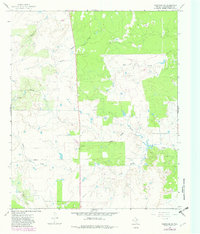
1966 Map of Westover SW
USGS Topo · Published 1982About this map
Travis and the surrounding rangeland of Throckmorton County define this mid-1960s landscape, later updated in the early 1980s. The map reveals an economy driven by petroleum extraction, with a significant Oil Field and various Oil Wells peppered throughout the territory. The intricate network of drainage is a primary feature, where Wagon Creek and Hog Creek carve through the terrain. A major Pipeline cuts across the southern portion of the quadrangle, highlighting the industrial infrastructure that shares the land with more traditional cattle country. Waterways like North Boggy Creek and Flat Creek provide the necessary relief for this part of West Texas, while labels for a Drill Hole point to the ongoing exploration that shaped the local history during the mid-century energy boom.
Find a feature on this map
13 named features on this map. Tap any name to fly to it.
Don’t see what you’re looking for? This feature index may not catch every label — zoom into the map to look around manually.
Map Details
Editions of this 1966 Westover SW Map
2 editions found
Other maps of this area

1954 · Wichita Falls
USGS Topo · 1:250,000

1958 · Wichita Falls
USGS Topo · 1:250,000

1962 · Antelope Creek SE
USGS Topo · 1:24,000

1962 · Antelope Creek NE
USGS Topo · 1:24,000

1965 · Throckmorton NE
USGS Topo · 1:24,000

1966 · Westover SE
USGS Topo · 1:24,000

1966 · Rock Canyon
USGS Topo · 1:24,000

1966 · Westover SW
USGS Topo · 1:24,000

1966 · Tonk Creek
USGS Topo · 1:24,000
1966 · Throckmorton
USGS Topo · 1:24,000