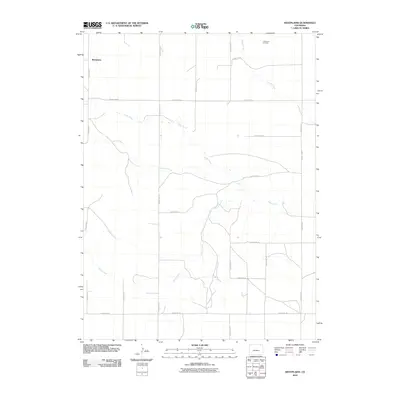
2010 Map of Westplains
USGS Topo · Published 2010About this map
Westplains anchors this corner of Logan County, positioned within a landscape defined by an extensive grid of section-line roads and seasonal drainage systems. The northern reaches of the quadrangle feature the Little Hoot Oil Field, indicating the importance of energy extraction in this high plains environment during the early 21st century. The terrain is etched by several watercourses including Cedar Creek and Twomile Creek, while the meandering path of Brush Creek winds through the southwestern and central sections. This network of unpaved county roads, such as County Rd-9 and County Rd-17, provides a precise look at the rural property divisions and accessibility of the region before any major modern suburban development reached this area.
Find a feature on this map
21 named features on this map. Tap any name to fly to it.
Don’t see what you’re looking for? This feature index may not catch every label — zoom into the map to look around manually.
Map Details
Editions of this 2010 Westplains Map
This is the sole edition of this map. No revisions or reprints were ever made.
Other maps of this area

1951 · Wild Horse Lake
USGS Topo · 1:24,000

1951 · Atwood NE
USGS Topo · 1:24,000

1954 · Sterling
USGS Topo · 1:250,000

1958 · Sterling
USGS Topo · 1:250,000

1977 · Dipper Spring
USGS Topo · 1:24,000

1977 · Stoneham NE
USGS Topo · 1:24,000

1977 · Avalo SE
USGS Topo · 1:24,000
1978 · Kirchnavy Butte
USGS Topo · 1:24,000
1978 · Chimney Canyons
USGS Topo · 1:24,000
1978 · North Sterling Reservoir
USGS Topo · 1:24,000