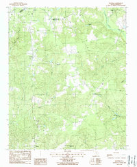
1988 Map of Westville
USGS Topo · Published 1988About this map
The Little Lynches River carves through this northern South Carolina landscape, defining a rural region marked by its legacy of small-scale industry and milling. Along the eastern boundary of Westville, the terrain is punctuated by historical milling sites including Kirkley Mill and Barfield Mill, while Gaston Mill sits further south along Quarter Creek. This era of the 1980s captures a mix of traditional land use and mid-century transitions, visible in the Abandoned Landing Strip near the Lancaster County line and the active Lockhart Oil Field to the east.
Find a feature on this map
27 named features on this map. Tap any name to fly to it.
Don’t see what you’re looking for? This feature index may not catch every label — zoom into the map to look around manually.
Map Details
Editions of this 1988 Westville Map
This is the sole edition of this map. No revisions or reprints were ever made.
Other maps of this area

1935 · Camden
USGS Topo · 1:48,000

1938 · Camden
USGS Topo · 1:62,500

1941 · Spartanburg
USGS Topo · 1:250,000

1942 · Camden
USGS Topo · 1:125,000

1953 · Spartanburg
USGS Topo · 1:250,000

1960 · Spartanburg
USGS Topo · 1:250,000

1963 · Spartanburg
USGS Topo · 1:250,000

1964 · Spartanburg
USGS Topo · 1:250,000

1967 · Mount Pisgah
USGS Topo · 1:24,000

1968 · Heath Springs
USGS Topo · 1:24,000