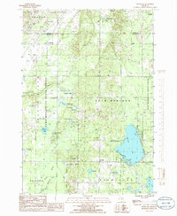
1985 Map of Westwood
USGS Topo · Published 1986About this map
Manistee Lake serves as a central hydrological feature in this portion of Kalkaska County, bordered by the extensive Pere Marquette State Forest and Mackinaw State Forest. The mid-1980s landscape is defined by its transition from high upland areas in the north toward the swampy lowlands of the Mahan River and the North Branch Boardman River valley in the south. Small settlements like Westwood and Darragh are interconnected by a network of local roads and an Old RR Grade, reflecting a history of timber extraction and transport.
Find a feature on this map
39 named features on this map. Tap any name to fly to it.
Don’t see what you’re looking for? This feature index may not catch every label — zoom into the map to look around manually.
Map Details
Editions of this 1985 Westwood Map
This is the sole edition of this map. No revisions or reprints were ever made.
Other maps of this area

1949 · Black Creek
USGS Topo · 1:24,000

1949 · Fletcher
USGS Topo · 1:62,500

1954 · Traverse City
USGS Topo · 1:250,000

1956 · Alba
USGS Topo · 1:62,500

1956 · Mancelona
USGS Topo · 1:62,500

1956 · Kalkaska
USGS Topo · 1:62,500

1958 · Traverse City
USGS Topo · 1:250,000

1975 · Mancelona NE
USGS Topo · 1:24,000

1975 · Mancelona NW
USGS Topo · 1:24,000

1983 · Traverse City
USGS Topo · 1:100,000
Featured Places
- Westwood, MI
- Excelsior Township, MI
- Coldsprings Township, MI
- Rapid River Township, MI
- Kalkaska Township, MI