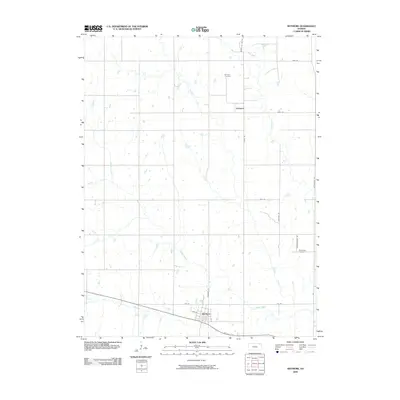
2009 Map of Wetmore
USGS Topo · Published 2009About this map
Wetmore serves as the primary hub in this corner of Nemaha County, where the street grid of the town center meets the surrounding agricultural landscape. The area is defined by a dense network of sectional roads and the meandering paths of several waterways, including Wolfley Creek and Muddy Creek, which drain the rolling terrain. The map documents the persistent rural character of the region, anchored by established locations such as Granada and its nearby Granada Cemetery. Further east, the Powhattan Cemetery stands as another significant local landmark. This 2009 survey highlights how modern infrastructure, like the route along Nebraska St, integrates with natural features such as Spring Creek and Barnes Creek to shape the current settlement patterns of the Kansas plains.
Find a feature on this map
23 named features on this map. Tap any name to fly to it.
Don’t see what you’re looking for? This feature index may not catch every label — zoom into the map to look around manually.
Map Details
Editions of this 2009 Wetmore Map
This is the sole edition of this map. No revisions or reprints were ever made.
Other maps of this area

1888 · Hiawatha
USGS Topo · 1:125,000

1894 · Hiawatha
USGS Topo · 1:125,000

1950 · Kansas City
USGS Topo · 1:250,000

1954 · Kansas City
USGS Topo · 1:250,000

1956 · Kansas City
USGS Topo · 1:250,000

1960 · Kansas City
USGS Topo · 1:250,000

1960 · Fairview
USGS Topo · 1:24,000
1960 · Horton NW
USGS Topo · 1:24,000
1961 · Netawaka
USGS Topo · 1:24,000
1961 · Circleville
USGS Topo · 1:24,000