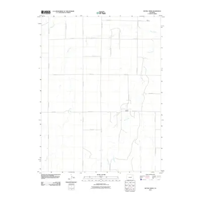
2010 Map of Wetzel Creek
USGS Topo · Published 2010About this map
Wetzel Creek and its neighboring waterways, Beaver Creek and Badger Creek, carve a subtle drainage pattern across this section of the high plains. The landscape is defined by a rigid grid of section roads and thoroughfares, including Meridian Rd and Winview Mile Rd, which partition the territory into large agricultural blocks. A notable point of historical interest is Swan Cemetery, located in the northeast corner along County Rd-21, serving as a silent anchor for the area's rural genealogy. The map also documents the industrial footprint of the region, specifically at the Big Beaver Oil Field near the junction of County Rd-16 and County Road C 5. This alignment of energy extraction and traditional farming suggests an economy in transition, where late-20th-century infrastructure overlays the original homestead-era road network.
Find a feature on this map
25 named features on this map. Tap any name to fly to it.
Don’t see what you’re looking for? This feature index may not catch every label — zoom into the map to look around manually.
Map Details
Editions of this 2010 Wetzel Creek Map
This is the sole edition of this map. No revisions or reprints were ever made.
Other maps of this area

1954 · Limon
USGS Topo · 1:250,000

1957 · Limon
USGS Topo · 1:250,000

1958 · Limon
USGS Topo · 1:250,000

1973 · Woodrow
USGS Topo · 1:24,000

1973 · Shamrock
USGS Topo · 1:24,000

1973 · Last Chance NW
USGS Topo · 1:24,000
1973 · Woodrow NW
USGS Topo · 1:24,000

1973 · Last Chance
USGS Topo · 1:24,000
1973 · Cottonwood Valley North
USGS Topo · 1:24,000

1973 · Wetzel Creek
USGS Topo · 1:24,000