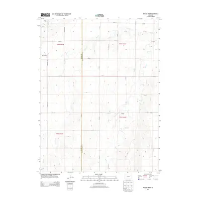
2013 Map of Wetzel Creek
USGS Topo · Published 2013About this map
Wetzel Cr and Beaver Cr carve subtle drainage patterns across this eastern Colorado high plains landscape on the border of Adams and Washington counties. The area is characterized by large-scale agricultural operations and energy extraction, evidenced by Causey Farms, Baker Farm, and the Big Beaver Oil Field. A straight grid of county roads, such as Co Road A and Co Road 18, defines the property boundaries and township lines of this rural expanse. Local history and genealogy interests are anchored by the Swan Cem in the northeast and the Morris Airport to the west. This 2013 survey captures a transition point in the region's land use, where traditional ranching and farming coexist with modern aviation and petroleum interests.
Find a feature on this map
33 named features on this map. Tap any name to fly to it.
Don’t see what you’re looking for? This feature index may not catch every label — zoom into the map to look around manually.
Map Details
Editions of this 2013 Wetzel Creek Map
This is the sole edition of this map. No revisions or reprints were ever made.
Other maps of this area

1954 · Limon
USGS Topo · 1:250,000

1957 · Limon
USGS Topo · 1:250,000

1958 · Limon
USGS Topo · 1:250,000

1973 · Woodrow
USGS Topo · 1:24,000

1973 · Shamrock
USGS Topo · 1:24,000

1973 · Last Chance NW
USGS Topo · 1:24,000
1973 · Woodrow NW
USGS Topo · 1:24,000

1973 · Last Chance
USGS Topo · 1:24,000
1973 · Cottonwood Valley North
USGS Topo · 1:24,000

1973 · Wetzel Creek
USGS Topo · 1:24,000