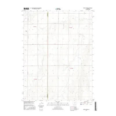
2016 Map of Wetzel Creek
USGS Topo · Published 2016About this map
The high plains of eastern Colorado are defined by the convergence of the Adams Co Washington Co boundary, where straight sections and township lines meet the meandering drainages of Wetzel Creek and Beaver Cr. This 2016 survey documents a landscape dominated by agriculture and sparse ranching infrastructure, punctuated by family-named landmarks like Swan Cem and the small Morris Airport. The road network is organized on a strict grid of county roads and named corridors such as Meridian Rd and Winview Mile Rd, which provide access to the vast open sections between the seasonal watercourses. The inclusion of Badger Cr in the northwest corner highlights the subtle topographical shifts of the area as it slopes toward the South Platte River basin, illustrating how surveyors and early settlers adapted to the arid terrain through meticulous sectioning and road planning.
Find a feature on this map
32 named features on this map. Tap any name to fly to it.
Don’t see what you’re looking for? This feature index may not catch every label — zoom into the map to look around manually.
Map Details
Editions of this 2016 Wetzel Creek Map
This is the sole edition of this map. No revisions or reprints were ever made.
Other maps of this area

1954 · Limon
USGS Topo · 1:250,000

1957 · Limon
USGS Topo · 1:250,000

1958 · Limon
USGS Topo · 1:250,000

1973 · Woodrow
USGS Topo · 1:24,000

1973 · Shamrock
USGS Topo · 1:24,000

1973 · Last Chance NW
USGS Topo · 1:24,000
1973 · Woodrow NW
USGS Topo · 1:24,000

1973 · Last Chance
USGS Topo · 1:24,000
1973 · Cottonwood Valley North
USGS Topo · 1:24,000

1973 · Wetzel Creek
USGS Topo · 1:24,000