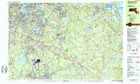
1984 Map of Weymouth
USGS Topo · Published 1984About this map
South Weymouth Naval Air Station occupies a significant footprint in the southern portion of this landscape, its runways and facilities standing as a major defense landmark during the mid-1980s. The surrounding terrain in Norfolk and Plymouth Counties is a dense network of suburban residential pockets like East Weymouth, Lovell Corners, and South Hingham interspersed with extensive protected lands. The presence of Wompatuck State Park and the U S Government Reservation preserves a large swath of woodland and swamp, including Dead Swamp and Valley Swamp, which contrast with the industrial activity along the Fore River and Weymouth Back River. For genealogists, the map identifies numerous small burial grounds and parish landmarks such as Village Cem, St Marys Cem, and Maryknoll Seminary. The coastal edge is defined by Hingham Harbor and Town River Bay, while the Penn Central rail lines and State Hwy 3 facilitate the heavy commuter flow toward Quincy and Boston.
Find a feature on this map
199 named features on this map. Tap any name to fly to it.
Don’t see what you’re looking for? This feature index may not catch every label — zoom into the map to look around manually.
Map Details
Editions of this 1984 Weymouth Map
2 editions found
Other maps of this area

1885 · Abington
USGS Topo · 1:62,500

1885 · Duxbury
USGS Topo · 1:62,500

1886 · Dedham
USGS Topo · 1:62,500

1888 · Duxbury
USGS Topo · 1:62,500

1888 · Abington
USGS Topo · 1:62,500

1892 · Boston Bay
USGS Topo · 1:62,500

1893 · Abington
USGS Topo · 1:62,500

1893 · Boston
USGS Topo · 1:62,500

1893 · Duxbury
USGS Topo · 1:62,500

1894 · Dedham
USGS Topo · 1:62,500