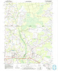
1992 Map of Whaleysville
USGS Topo · Published 1992About this map
Cypress Swamp dominates the upper reach of this landscape, where the Pocomoke River winds southward through a network of intricate drainages like Grays Prong and Little Newfound Branch. The terrain is defined by low-lying necks and ridges, including Big Newfound Neck and Pine Ridge, which shaped the early agricultural and settlement patterns of the Maryland-Delaware border. Small rural communities are scattered throughout, most notably Whaleysville and Willards, the latter featuring the Willards Sch. Genealogy and local history are preserved in family and community landmarks such as Pulletts Chapel and Bethel Cem. The transition from swamp to settled land is marked by an extensive system of ditches, including Davis Ditch, reflecting the long-term engineering required to manage this coastal plain environment for farming and habitation.
Find a feature on this map
73 named features on this map. Tap any name to fly to it.
Don’t see what you’re looking for? This feature index may not catch every label — zoom into the map to look around manually.
Map Details
Editions of this 1992 Whaleysville Map
This is the sole edition of this map. No revisions or reprints were ever made.
Other maps of this area

1901 · Ocean City
USGS Topo · 1:62,500

1902 · Pittsville
USGS Topo · 1:62,500

1917 · Millsboro
USGS Topo · 1:62,500

1918 · Rehoboth
USGS Topo · 1:62,500

1938 · Millsboro
USGS Topo · 1:62,500

1938 · Rehoboth
USGS Topo · 1:62,500

1942 · Ocean City
USGS Topo · 1:62,500

1942 · Ninepin
USGS Topo · 1:24,000

1942 · Wango
USGS Topo · 1:24,000

1942 · Whaleysville
USGS Topo · 1:24,000