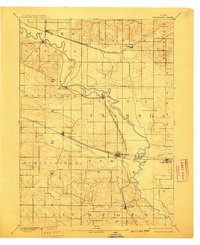
1894 Map of Wheatland
USGS Topo · Published 1910About this map
The Wapsipinicon River meanders across this eastern Iowa landscape, serving as a natural boundary and vital water source for the nineteenth-century agricultural townships of Jones, Clinton, and Scott. The era's transportation network is defined by two major rail lines, the Chicago Milwaukee and St Paul Railroad and the Chicago and North Western Railroad, which dictated the growth of local trade centers. The settlement pattern shows a concentration of activity at critical rail junctions and river crossings, particularly at Wheatland and Oxford Junction. Smaller hubs like Oxford Mills and Massillon sit along the winding riverbanks, while Lost Nation and Lowden represent the upland prairie towns supported by the burgeoning railroad industry. Topographer W.J. Peters recorded this territory just as the modern grid of sections and local roads began to firmly establish the rural character of the region.
Find a feature on this map
25 named features on this map. Tap any name to fly to it.
Don’t see what you’re looking for? This feature index may not catch every label — zoom into the map to look around manually.
Map Details
Editions of this 1894 Wheatland Map
2 editions found

Other maps of this area

1889 · Tipton
USGS Topo · 1:62,500

1890 · Durant
USGS Topo · 1:62,500

1890 · Tipton
USGS Topo · 1:62,500

1891 · DeWitt
USGS Topo · 1:62,500

1891 · Davenport
USGS Topo · 1:62,500

1891 · Monticello
USGS Topo · 1:62,500

1891 · Maquoketa
USGS Topo · 1:62,500

1891 · Wilton Junction
USGS Topo · 1:62,500

1891 · Baldwin
USGS Topo · 1:62,500

1892 · Wheatland
USGS Topo · 1:62,500