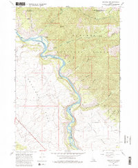
1966 Map of Wheaton Mountain
USGS Topo · Published 1981About this map
The Snake River carves a deep, winding course through the heart of the Targhee National Forest in this mid-1960s survey of the Idaho backcountry. The river's path is marked by river-mile markers and distinct topographical features such as Fisher Bottom and Lufkin Bottom, which stand in contrast to the steep canyon walls and numerous gulches. To the west, the landscape opens into the broad expanse of Antelope Flat, while the eastern portion is dominated by the complex drainage systems of Black Canyon, Garner Canyon, and Rocky Canyon. Historical access is illustrated by a network of Pack Trails and Jeep Trails that connect remote water sources like Lufkin Spring and Warm Springs to higher elevations including Wheaton Mtn and Black Mountain. This map illustrates the transition from the relatively level Pine Creek Bench to the deeply eroded river breaks.
Find a feature on this map
37 named features on this map. Tap any name to fly to it.
Don’t see what you’re looking for? This feature index may not catch every label — zoom into the map to look around manually.
Map Details
Editions of this 1966 Wheaton Mountain Map
3 editions found
Other maps of this area

1924 · Hell Creek
USGS Topo · 1:62,500

1926 · Hell Creek
USGS Topo · 1:62,500

1932 · Irwin
USGS Topo · 1:96,000

1935 · Irwin
USGS Topo · 1:125,000

1943 · Garns Mtn
USGS Topo · 1:62,500

1946 · Garns Mtn
USGS Topo · 1:62,500

1951 · Hawley Gulch
USGS Topo · 1:24,000

1951 · Heise SE
USGS Topo · 1:24,000

1955 · Driggs
USGS Topo · 1:250,000

1958 · Driggs
USGS Topo · 1:250,000