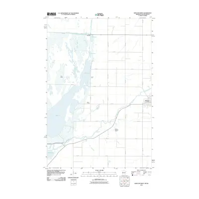
2010 Map of Wheaton West
USGS Topo · Published 2010About this map
Mud Lake dominates the central landscape of this western Minnesota border region, creating a complex wetland environment alongside the Bois de Sioux River. The area is defined by the convergence of several major water systems, including the Mustinka River and Big Slough, which feed into the northern reaches of Lake Traverse. This hydrography is managed in part by the White Rock Dam, a key piece of infrastructure near the South Dakota border.
Find a feature on this map
28 named features on this map. Tap any name to fly to it.
Don’t see what you’re looking for? This feature index may not catch every label — zoom into the map to look around manually.
Map Details
Editions of this 2010 Wheaton West Map
This is the sole edition of this map. No revisions or reprints were ever made.
Other maps of this area

1915 · White Rock
USGS Topo · 1:62,500

1916 · Beardsley
USGS Topo · 1:62,500

1918 · White Rock
USGS Topo · 1:62,500

1918 · Beardsley
USGS Topo · 1:62,500

1950 · Graceville
USGS Topo · 1:62,500

1951 · Wheaton
USGS Topo · 1:62,500

1953 · Milbank
USGS Topo · 1:250,000

1958 · Milbank
USGS Topo · 1:250,000
1972 · La Mars
USGS Topo · 1:24,000
1972 · Rosholt
USGS Topo · 1:24,000