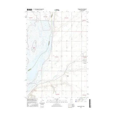
2016 Map of Wheaton West
USGS Topo · Published 2016About this map
The boundary between Minnesota and South Dakota defines the western edge of this landscape, where the waters of the Big Slough collect and drain toward the Mustinka River. Near the western outskirts of Wheaton, the terrain is marked by a grid of rural roads and the meandering path of Eighteenmile Cr, which cuts across the prairie towards the Wheaton Municipal Airport. This area represents a critical hydrological junction where agricultural drainage systems meet natural riverbeds in the Red River Valley. Local history and genealogy are anchored by the Nelson Cem, located near the intersection of 630th Ave and 660th St. The map illustrates the transition from the structured residential blocks of Wheaton to the sprawling section lines of the surrounding townships, providing a clear record of the region's land use and water management infrastructure.
Find a feature on this map
38 named features on this map. Tap any name to fly to it.
Don’t see what you’re looking for? This feature index may not catch every label — zoom into the map to look around manually.
Map Details
Editions of this 2016 Wheaton West Map
This is the sole edition of this map. No revisions or reprints were ever made.
Other maps of this area

1915 · White Rock
USGS Topo · 1:62,500

1916 · Beardsley
USGS Topo · 1:62,500

1918 · White Rock
USGS Topo · 1:62,500

1918 · Beardsley
USGS Topo · 1:62,500

1950 · Graceville
USGS Topo · 1:62,500

1951 · Wheaton
USGS Topo · 1:62,500

1953 · Milbank
USGS Topo · 1:250,000

1958 · Milbank
USGS Topo · 1:250,000
1972 · La Mars
USGS Topo · 1:24,000
1972 · Rosholt
USGS Topo · 1:24,000