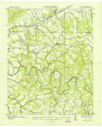
1935 Map of Wheeler
USGS Topo · Published 1935About this map
The Powell River meanders through Claiborne County in a series of sharp loops, including Ellison Bend and Massengill Bend, during this mid-1930s Tennessee Valley Authority compilation. The landscape is defined by the historic transit corridors of the Kentucky Wilderness Road and the Louisville and Nashville Railroad Company, which intersect near the Wheeler station and Gibson Sta PO. These routes trace the foot of Valley Ridge, where early 20th-century life centered on family-named nodes and small community hubs.
Find a feature on this map
76 named features on this map. Tap any name to fly to it.
Don’t see what you’re looking for? This feature index may not catch every label — zoom into the map to look around manually.
Map Details
Editions of this 1935 Wheeler Map
This is the sole edition of this map. No revisions or reprints were ever made.
Other maps of this area

1883 · Morristown
USGS Topo · 1:125,000

1886 · Cumberland Gap
USGS Topo · 1:125,000

1887 · Jonesville
USGS Topo · 1:125,000

1888 · Cumberland Gap
USGS Topo · 1:125,000

1891 · Cumberland Gap
USGS Topo · 1:125,000

1891 · Jonesville
USGS Topo · 1:125,000

1893 · Morristown
USGS Topo · 1:125,000

1895 · Morristown
USGS Topo · 1:125,000

1897 · Maynardville
USGS Topo · 1:125,000

1900 · Maynardville
USGS Topo · 1:125,000