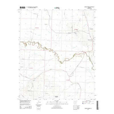
2014 Map of Whelen Springs
USGS Topo · Published 2014About this map
Whelen Springs and the surrounding timberlands of the Clark and Nevada county border are defined by the meandering course of the Little Missouri River. This riparian landscape is a network of water and relief, featuring distinctive bottomlands like Deep Slough and Hill Slough alongside the rising elevations of Whetstone Mtn and Rose Hill. The settlement pattern is characterized by small, dispersed communities such as Sycamore, Barringer, and Cummings Springs, each connected by a web of local routes including Nevada 16 RD and Ar 51. Genealogists will find significant value in the numerous documented burial sites, including Springhill Cem, Rose Hill Cem, and Sweet Home Cem. The presence of the Pipeline Loop and various forestry access roads like Log RD and Fishing Camp RD underscores the area's ongoing relationship with resource management and traditional river-bottom activities.
Find a feature on this map
58 named features on this map. Tap any name to fly to it.
Don’t see what you’re looking for? This feature index may not catch every label — zoom into the map to look around manually.
Map Details
Editions of this 2014 Whelen Springs Map
This is the sole edition of this map. No revisions or reprints were ever made.
Other maps of this area

1901 · Gurdon
USGS Topo · 1:125,000

1953 · El Dorado
USGS Topo · 1:250,000

1957 · El Dorado
USGS Topo · 1:250,000

1958 · El Dorado
USGS Topo · 1:250,000

1960 · El Dorado
USGS Topo · 1:250,000

1970 · Whelen Springs
USGS Topo · 1:24,000

1970 · Prescott East
USGS Topo · 1:24,000

1970 · Reader
USGS Topo · 1:24,000
1970 · Gurdon
USGS Topo · 1:24,000
1970 · Curtis
USGS Topo · 1:24,000