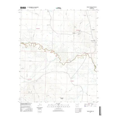
2017 Map of Whelen Springs
USGS Topo · Published 2017About this map
The Little Missouri River meanders across this part of Clark and Nevada counties, defining a landscape of low-lying sloughs and creek bottoms. In the south, Terre Rouge Creek and Caney Creek drain the bottomlands near Cummings Springs, while the northern portion of the quadrangle rises toward the lone peak of Whetstone Mtn. This area is characterized by a network of rural roads such as Goose Ankle Rd and Alligator Rd, connecting small settlements and isolated farmsteads. Several established family or community burial sites, including Sweet Home Cem and Rose Hill Cem, provide significant markers for genealogical research. The town of Whelen Springs sits on the eastern edge of the survey, serving as a focal point near the river's winding path through Deep Slough and Hill Slough.
Find a feature on this map
50 named features on this map. Tap any name to fly to it.
Don’t see what you’re looking for? This feature index may not catch every label — zoom into the map to look around manually.
Map Details
Editions of this 2017 Whelen Springs Map
This is the sole edition of this map. No revisions or reprints were ever made.
Other maps of this area

1901 · Gurdon
USGS Topo · 1:125,000

1953 · El Dorado
USGS Topo · 1:250,000

1957 · El Dorado
USGS Topo · 1:250,000

1958 · El Dorado
USGS Topo · 1:250,000

1960 · El Dorado
USGS Topo · 1:250,000

1970 · Whelen Springs
USGS Topo · 1:24,000

1970 · Prescott East
USGS Topo · 1:24,000

1970 · Reader
USGS Topo · 1:24,000
1970 · Gurdon
USGS Topo · 1:24,000
1970 · Curtis
USGS Topo · 1:24,000