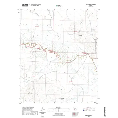
2020 Map of Whelen Springs
USGS Topo · Published 2020About this map
The Little Missouri River snakes through the center of this southern Arkansas landscape, forming a complex boundary between Clark and Nevada Counties. Dense wetlands and oxbows, including Deep Slough and Long Slough, define the river's path, reflecting the seasonal hydrology of the region. On the northern banks, the settlement of Sycamore and the higher ground of Whetstone Mtn provide a contrast to the river bottomlands. This area is characterized by a mix of timberlands and rural homesteads, connected by a network of county roads like Co Rd 418 and Co Rd 409.
Find a feature on this map
48 named features on this map. Tap any name to fly to it.
Don’t see what you’re looking for? This feature index may not catch every label — zoom into the map to look around manually.
Map Details
Editions of this 2020 Whelen Springs Map
This is the sole edition of this map. No revisions or reprints were ever made.
Other maps of this area

1901 · Gurdon
USGS Topo · 1:125,000

1953 · El Dorado
USGS Topo · 1:250,000

1957 · El Dorado
USGS Topo · 1:250,000

1958 · El Dorado
USGS Topo · 1:250,000

1960 · El Dorado
USGS Topo · 1:250,000

1970 · Whelen Springs
USGS Topo · 1:24,000

1970 · Prescott East
USGS Topo · 1:24,000

1970 · Reader
USGS Topo · 1:24,000
1970 · Gurdon
USGS Topo · 1:24,000
1970 · Curtis
USGS Topo · 1:24,000