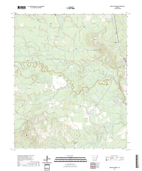
2024 Map of Whelen Springs
USGS Topo · Published 2024About this map
The Little Missouri River snakes through the center of this landscape, forming the natural boundary between Clark and Nevada Counties. The region is defined by a complex network of waterways, including the sluggish waters of Long Slough, Deep Slough, and Hill Slough that parallel the river's course. Small rural settlements like Whelen Springs, Sycamore, and Barringer anchor the local geography, while numerous family and community burial grounds such as Shady Grove Cem, Sweet Home Cem, and Rose Hill Cem provide essential touchpoints for genealogical research. The terrain rises to Whetstone Mtn in the north, contrasting with the low-lying basin of Terre Rouge Creek to the south. An intricate system of timber and utility roads, including the Pipeline Loop and various numbered cabin trails, suggests a landscape deeply tied to resource management and rural utility in the modern era.
Find a feature on this map
59 named features on this map. Tap any name to fly to it.
Don’t see what you’re looking for? This feature index may not catch every label — zoom into the map to look around manually.
Map Details
Editions of this 2024 Whelen Springs Map
This is the sole edition of this map. No revisions or reprints were ever made.
Other maps of this area

1901 · Gurdon
USGS Topo · 1:125,000

1953 · El Dorado
USGS Topo · 1:250,000

1957 · El Dorado
USGS Topo · 1:250,000

1958 · El Dorado
USGS Topo · 1:250,000

1960 · El Dorado
USGS Topo · 1:250,000

1970 · Whelen Springs
USGS Topo · 1:24,000

1970 · Prescott East
USGS Topo · 1:24,000

1970 · Reader
USGS Topo · 1:24,000
1970 · Gurdon
USGS Topo · 1:24,000
1970 · Curtis
USGS Topo · 1:24,000