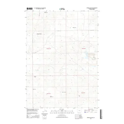
2015 Map of Whipple Hollow
USGS Topo · Published 2015About this map
Whipple Hollow and the elevated plains of the Wyoming high country define this Converse County landscape in the mid-2010s. The terrain is characterized by a series of named drainages and expansive plateaus, including Highland Flats and Taylor Flats, which transition into more complex topographical features like Box Creek Divide. Water is scarce but vital, marked by the presence of Buck Reservoir and seasonal drainages such as Spillman Draw and School Section Draw. These features suggest a ranching landscape where land management relies on natural contours and named watercourses like Willow Creek and North Fork Box Creek. Transport in this part of the state remains focused on established routes such as WY-93 and Willow Creek Road, facilitating movement across the sparsely populated townships. The map provides a clear look at the public land survey system, with sections and range lines clearly demarcated across the diverse drainage systems of Skunk Creek and Dry Draw.
Find a feature on this map
19 named features on this map. Tap any name to fly to it.
Don’t see what you’re looking for? This feature index may not catch every label — zoom into the map to look around manually.
Map Details
Editions of this 2015 Whipple Hollow Map
This is the sole edition of this map. No revisions or reprints were ever made.
Other maps of this area

1949 · Sundquist Ranch
USGS Topo · 1:24,000

1949 · Gilbert Lake
USGS Topo · 1:24,000

1949 · Leuenberger Ranch
USGS Topo · 1:24,000

1950 · Gilbert Lake
USGS Topo · 1:24,000

1950 · Leuenberger Ranch
USGS Topo · 1:24,000
1950 · Sundquist Ranch
USGS Topo · 1:24,000

1954 · Torrington
USGS Topo · 1:250,000

1955 · Newcastle
USGS Topo · 1:250,000

1958 · Torrington
USGS Topo · 1:250,000

1958 · Newcastle
USGS Topo · 1:250,000