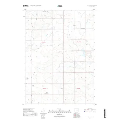
2017 Map of Whipple Hollow
USGS Topo · Published 2017About this map
Whipple Hollow and the surrounding high plains of Converse County are defined by a network of seasonal drainages and flat-topped divides. The landscape is structured by significant geological markers such as Box Creek Divide and the broad expanses of Highland Flats and Taylor Flats. Water management in this arid environment is evident through features like Buck Reservoir and the various forks of Willow Cr and N Fork Box Cr.
Find a feature on this map
19 named features on this map. Tap any name to fly to it.
Don’t see what you’re looking for? This feature index may not catch every label — zoom into the map to look around manually.
Map Details
Editions of this 2017 Whipple Hollow Map
This is the sole edition of this map. No revisions or reprints were ever made.
Other maps of this area

1949 · Sundquist Ranch
USGS Topo · 1:24,000

1949 · Gilbert Lake
USGS Topo · 1:24,000

1949 · Leuenberger Ranch
USGS Topo · 1:24,000

1950 · Gilbert Lake
USGS Topo · 1:24,000

1950 · Leuenberger Ranch
USGS Topo · 1:24,000
1950 · Sundquist Ranch
USGS Topo · 1:24,000

1954 · Torrington
USGS Topo · 1:250,000

1955 · Newcastle
USGS Topo · 1:250,000

1958 · Torrington
USGS Topo · 1:250,000

1958 · Newcastle
USGS Topo · 1:250,000