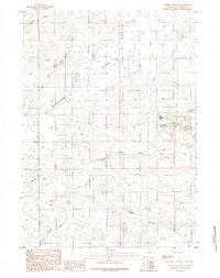
1984 Map of Whipple Hollow
USGS Topo · Published 1984About this map
Highland Flats and Taylor Flats dominate this landscape in central Wyoming, where the high plains are carved by a network of seasonal watercourses. The 1984 survey reveals a ranching-focused economy centered around landmarks like the Leuenberger Ranch and Sandpoint Ranch. The distribution of water is a primary theme of the map, as evidenced by the numerous named stock ponds and catchment areas including Antelope Reservoir and Fawn Reservoir.
Find a feature on this map
17 named features on this map. Tap any name to fly to it.
Don’t see what you’re looking for? This feature index may not catch every label — zoom into the map to look around manually.
Map Details
Editions of this 1984 Whipple Hollow Map
This is the sole edition of this map. No revisions or reprints were ever made.
Other maps of this area

1949 · Sundquist Ranch
USGS Topo · 1:24,000

1949 · Gilbert Lake
USGS Topo · 1:24,000

1949 · Leuenberger Ranch
USGS Topo · 1:24,000

1950 · Gilbert Lake
USGS Topo · 1:24,000

1950 · Leuenberger Ranch
USGS Topo · 1:24,000
1950 · Sundquist Ranch
USGS Topo · 1:24,000

1954 · Torrington
USGS Topo · 1:250,000

1955 · Newcastle
USGS Topo · 1:250,000

1958 · Torrington
USGS Topo · 1:250,000

1958 · Newcastle
USGS Topo · 1:250,000