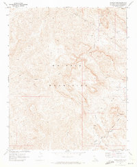
1970 Map of Whipple Wash
USGS Topo · Published 1973About this map
The Whipple Mountains dominate this California landscape, where complex geological formations and deep desert drainages define the area north of the Colorado River. Notable for its industrial and mining footprint during the early 1970s, the map identifies the Colorado River Aqueduct Tunnel traversing the southern portion of the range, an essential piece of regional water infrastructure. Mining activity is evident through the presence of the Islander Mine, the Whipple Mtn Adit, and various unnamed mines and prospects scattered across the high ground. The eastern section of the quadrangle includes the Colorado River Indian Reservation Boundary, marking the edge of tribal lands. Major natural features like Copper Basin and the prominent Monument Peak anchor the topography, while a network of jeep trails and the Copper Basin Trail provide the primary means of navigating this arid terrain.
Find a feature on this map
18 named features on this map. Tap any name to fly to it.
Don’t see what you’re looking for? This feature index may not catch every label — zoom into the map to look around manually.
Map Details
Editions of this 1970 Whipple Wash Map
2 editions found
Other maps of this area

1911 · Parker
USGS Topo · 1:125,000

1943 · Giers Basin
USGS Topo · 1:62,500

1943 · Whipple Mts.
USGS Topo · 1:62,500

1943 · Parker
USGS Topo · 1:62,500

1949 · Parker
USGS Topo · 1:62,500

1950 · Parker Dam Area
USGS Topo · 1:62,500

1950 · Parker
USGS Topo · 1:62,500

1950 · Whipple Mts
USGS Topo · 1:62,500

1952 · Whipple Mts
USGS Topo · 1:62,500

1954 · Needles
USGS Topo · 1:250,000