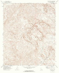
1970 Map of Whipple Wash
USGS Topo · Published 1973About this map
Whipple Mountains dominate this 1970 landscape, carved by the deep drainage systems of Whipple Wash, Bennett Wash, and Bowmans Wash. This arid stretch of San Bernardino County reveals a mid-century desert environment defined by mineral exploration and large-scale water infrastructure. The presence of the Colorado River Aqueduct Tunnel and a nearby Substation reflects the technological efforts to move water across the Mojave. Evidence of prospectors and mining activity is scattered across the terrain, from the Islander Mine in the north to the Whipple Mtn Adit and various unnamed Mine and Prospect symbols. The eastern portion is marked by the Colorado River Indian Reservation Boundary, while prominent peaks like Monument Peak provide significant navigational landmarks in a region largely accessed by a network of Jeep Trails.
Find a feature on this map
17 named features on this map. Tap any name to fly to it.
Don’t see what you’re looking for? This feature index may not catch every label — zoom into the map to look around manually.
Map Details
Editions of this 1970 Whipple Wash Map
2 editions found
Other maps of this area

1911 · Parker
USGS Topo · 1:125,000

1943 · Giers Basin
USGS Topo · 1:62,500

1943 · Whipple Mts.
USGS Topo · 1:62,500

1943 · Parker
USGS Topo · 1:62,500

1949 · Parker
USGS Topo · 1:62,500

1950 · Parker Dam Area
USGS Topo · 1:62,500

1950 · Parker
USGS Topo · 1:62,500

1950 · Whipple Mts
USGS Topo · 1:62,500

1952 · Whipple Mts
USGS Topo · 1:62,500

1954 · Needles
USGS Topo · 1:250,000