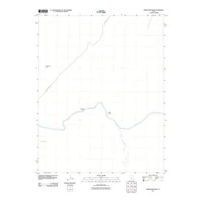
2011 Map of Whirlwind Draw
USGS Topo · Published 2011About this map
The San-Juan-River carves a deep path through this corner of San Juan County, Utah, defining the geography of a desert landscape shaped by ancient watercourses. The map highlights the significant elevation changes found at the Red House Cliffs in the northwest, providing a stark backdrop to the drainage systems that feed into the river. Movement through this arid region is primarily facilitated by the Whirlwind Crossing Rd, which traverses the high ground before descending toward the river valley. Smaller hydrological features like Nancys Pool and seasonal draws such as Whirlwind Draw and Steer Gulch offer localized insights into the drainage patterns of the Colorado Plateau. Further south, the prominent Oljato Wash joins the river system, illustrating the complex network of ephemeral streams that dominate this desert environment.
Find a feature on this map
7 named features on this map. Tap any name to fly to it.
Don’t see what you’re looking for? This feature index may not catch every label — zoom into the map to look around manually.
Map Details
Editions of this 2011 Whirlwind Draw Map
This is the sole edition of this map. No revisions or reprints were ever made.
Other maps of this area

1886 · Henry Mountains
USGS Topo · 1:250,000

1892 · Henry Mountains
USGS Topo · 1:250,000

1952 · Clay Hills 3 NW
USGS Topo · 1:24,000

1952 · Oljeto
USGS Topo · 1:62,500

1954 · Clay Hills 2 SW
USGS Topo · 1:24,000

1954 · Clay Hills 2 NW
USGS Topo · 1:24,000
1954 · Clay Hills 3 NE
USGS Topo · 1:24,000

1954 · Clay Hills 2 NE
USGS Topo · 1:24,000

1954 · Clay Hills 2 SE
USGS Topo · 1:24,000

1954 · Clay Hills 1 NW
USGS Topo · 1:24,000