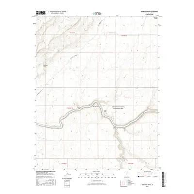
2017 Map of Whirlwind Draw
USGS Topo · Published 2017About this map
San Juan River meanders through the heart of this high desert landscape, cutting deep through the geological layers of the San Juan Valley. This 2017 study illustrates the dramatic topography of the Glen Canyon National Recreation Area, where sharp elevation changes define features like the Red House Cliffs and the elevated Red Rock Plateau. The map highlights a critical river-crossing corridor marked by Whirlwind Crossing Road, which descends through Whirlwind Draw toward the water. Beyond the primary river channel, smaller hydrological features like Nancys Pool and drainage systems including Steer Gulch and Oljeto Wash show how water has shaped the sandstone terrain. The land is strictly partitioned by the Public Land Survey System into townships and ranges, underscoring the formal administrative boundaries overlaying this remote canyon country.
Find a feature on this map
17 named features on this map. Tap any name to fly to it.
Don’t see what you’re looking for? This feature index may not catch every label — zoom into the map to look around manually.
Map Details
Editions of this 2017 Whirlwind Draw Map
This is the sole edition of this map. No revisions or reprints were ever made.
Other maps of this area

1886 · Henry Mountains
USGS Topo · 1:250,000

1892 · Henry Mountains
USGS Topo · 1:250,000

1952 · Clay Hills 3 NW
USGS Topo · 1:24,000

1952 · Oljeto
USGS Topo · 1:62,500

1954 · Clay Hills 2 SW
USGS Topo · 1:24,000

1954 · Clay Hills 2 NW
USGS Topo · 1:24,000
1954 · Clay Hills 3 NE
USGS Topo · 1:24,000

1954 · Clay Hills 2 NE
USGS Topo · 1:24,000

1954 · Clay Hills 2 SE
USGS Topo · 1:24,000

1954 · Clay Hills 1 NW
USGS Topo · 1:24,000